


Researchers say a shift in how storms organize is raising flood risk in many regions. When clouds gather into tight clusters, rainfall intensifies and lingers. The effect has hit cities and rural areas with sudden, deadly floods. Scientists say the pattern is showing up more often as oceans and air warm.
The warning comes as emergency managers report more high-end rain events. Forecasters are studying how clustered storm cells feed on local heat and moisture. The goal is faster alerts and better planning for drainage, dams, and streets.
What Scientists Are Seeing
“Clumping clouds supercharge storms in surprising ways — driving heavy, deadly rainfall and flooding,” researchers report.
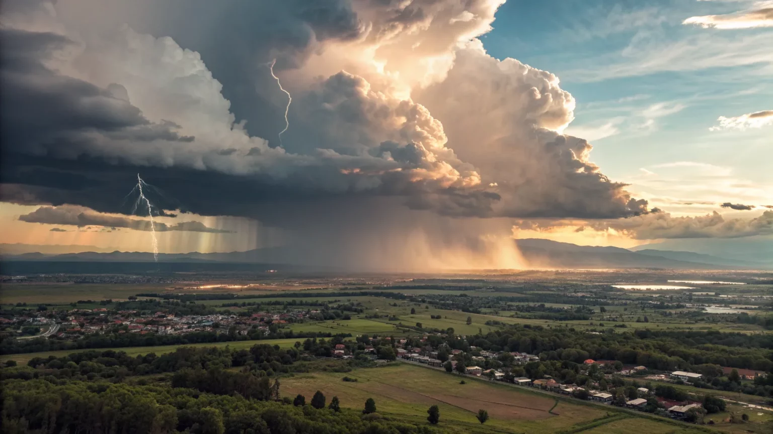
Teams studying radar and satellite data have tracked clusters of thunderstorms forming tight-knit groups. These clusters act like one large engine. Warm, moist air rises in one area and fuels nearby cells, pulling more moisture into the system.
The process is often called cloud clustering or convective aggregation. It can turn a routine downpour into a slow-moving flood threat. Storms may “train,” with repeated cells passing over the same spot for hours.
Why Clustering Matters
Moisture increases with heat. Physics shows air can hold about 7 percent more water for each 1 degree Celsius of warming. That extra moisture can fall fast when storms concentrate. Tight clusters also create their own wind flows, keeping the rain machine running.
- Clusters pull in surface moisture and recycle it.
- Storm outflows collide, sparking new cells.
- Weak steering winds let clusters sit over one area.
Urban areas face added danger. Paved surfaces shed water quickly, and drainage can be overwhelmed by short, intense bursts. Rural valleys and burn scars are also at risk when runoff speeds downhill.
Recent Floods Offer Clues
Case studies from the past decade tie flood disasters to storm clustering. In April 2023, Fort Lauderdale, Florida, recorded nearly 26 inches of rain in one day. Radar showed repeated cells forming and stalling over the city. In July 2023, parts of Vermont saw days of training storms. Rivers surged after round after round of rain.
Abroad, similar patterns have played out. Pakistan’s 2022 monsoon season brought extreme rainfall over large areas, with multi-day clusters feeding on high sea-surface temperatures. In Europe, summer storms have also stalled more often, swelling rivers and backing up urban drainage.


Long-term data point to a trend. The U.S. National Climate Assessment reports that the heaviest 1 percent of rain events have grown stronger since the mid-20th century, with the Northeast showing the largest increase. The Intergovernmental Panel on Climate Change has also linked warming to more intense downpours in many regions.
What Forecasters And Planners Are Doing
Meteorologists are refining models to track clustering earlier in the day. New satellite products and high-resolution models can spot boundary collisions and moisture streams. The aim is to flag training risks several hours ahead of time.
Emergency managers are updating flood maps and warning systems. Many cities are reassessing design standards for culverts, storm drains, and underpasses. Engineers say short-duration design storms may need higher targets. Insurance and mortgage risk models are being revised as well.
Community steps can reduce losses. Officials urge better maintenance of drains, more green space to soak up water, and limits on building in flood-prone zones. Agencies also stress clear communication when storms stall. Simple advice—turn around at flooded roads—still saves lives.
Debate And Uncertainty
Not every region will see the same changes. Wind patterns, terrain, and local water temperatures shape outcomes. Some experts caution that detection of clustering has improved, which can influence perceived trends.
Still, many studies agree on the direction of risk. Warmer seas feed tropical moisture plumes. Weak steering winds can trap clusters in place. As one research summary put it, the hazard is rising where moisture and slow movement meet.
What Comes Next
Scientists want more ground sensors and faster radar scans to track small features that trigger clustering. They are also testing forecasts that focus on “where and when training begins” rather than broad rain totals. The hope is to translate weather signals into street-level warnings.
For now, the message is clear. When clouds cluster, rainfall can jump from heavy to extreme. Cities and towns will need to plan for that step change. Early alerts, updated drainage, and smart land use can reduce the toll as storm patterns shift.
Expect more research on how warming, urban growth, and local wind patterns feed these clusters. Watch for advances in short-term forecasting and more precise flood warnings during stalled storms.