


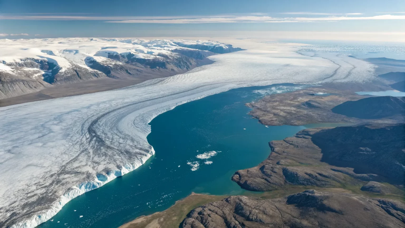
A stark satellite view from 2010 captures a fragile scene on Canada’s Baffin Island, where a small lake cuts through the rim of an ancient glacier. The image points to what scientists say is a solitary remnant of the ice that once blanketed much of the continent. It offers a clear, timely look at how quickly the Arctic is changing and why it matters now.
A 2010 satellite photo shows the point where a small lake bisects the snowy rim of an ancient glacier on Canada’s Baffin Island.
The rippling, snow-rimmed structure is the last remaining fragment of a colossal ice sheet that once covered large parts of North America.
Background On A Vanishing Ice Rim
Baffin Island sits in Nunavut, in Canada’s eastern Arctic. The island holds high plateaus and deep fjords, where cold once locked in thick ice. That ice was part of the Laurentide Ice Sheet, which stretched from the Arctic to the U.S. Midwest during the last Ice Age.
The Laurentide Ice Sheet retreated as the planet warmed after the last glacial maximum, roughly 20,000 years ago. Most of its mass had melted by about 10,000 years ago. Only scattered mountain and island glaciers remained.
Today, the circled rim described in the 2010 view is framed by snow and marked by meltwater. The lake slicing through it signals thinning ice and seasonal warmth reaching places once shielded by cold.
Why This Image Matters
Arctic regions are warming faster than the global average, a trend confirmed by decades of observations. Warmer air and oceans eat at ice edges, speed summer melt, and shorten the season of snow cover. That raises sea levels worldwide and changes local weather patterns.
Researchers point to features like the Baffin rim as sensitive indicators. A melt pond or a lake bisecting a rim can show how the glacier’s structure is weakening. It may also expose dark rock that absorbs more heat, speeding melt in the seasons ahead.
- Ice that once persisted year-round now sees longer melt seasons.
- New meltwater routes can fracture and drain ice faster.
- Exposed ground amplifies heat, reducing future snow cover.
Science Behind The Image
Satellite records help track change across remote terrain. Images from the late twentieth century into the 2010s show shrinking snowlines, expanding bare ground, and growing meltwater features on Baffin Island. The 2010 photo adds a clear sign: water cutting into the rim of an ancient glacier.
Glaciologists read these details to estimate mass loss and stability. A bisected rim may suggest lower ice thickness and warmer summers. It can also hint at earlier spring melt and later autumn freeze-up. Both shift local ecosystems and the timing of wildlife movement.


While a single image is not a full data set, it matches long-term trends reported across the Arctic. Taken with temperature records and field surveys, it strengthens the case that high-latitude ice is in retreat.
Local And Global Stakes
For Arctic communities, thinning ice changes travel safety and hunting routes. For the rest of the world, each kilogram of lost land ice adds to sea level rise. It also alters the balance of heat and light at the surface, which can affect regional weather far from the Arctic.
Scientists warn that small, high-latitude glaciers are especially sensitive. They can respond quickly to a few seasons of warmth. That makes them useful indicators, but also easy to lose before their signals are fully recorded.
What Comes Next
More frequent satellite passes and higher-resolution images will refine the view of Baffin Island’s ice. Field teams can pair those pictures with on-the-ground measurements of thickness, melt rate, and water pathways. Together, the methods can show whether the rim is stable, thinning slowly, or nearing a break.
Tracking such features also informs coastal planning far away. Better ice forecasts can improve sea level projections and help communities prepare. They can guide conservation efforts in Arctic habitats now facing warmer and longer summers.
The 2010 view of a lake slicing through an ancient rim offers a simple, powerful message: change is visible, even from space. The last fragment of a once-massive ice sheet now serves as a marker for a warming Arctic. The next few years will show whether that rim endures, fractures, or fades—and what that will signal for ice across the north.